From Nain Singh Rawat’s secret journeys to Kinthup’s extraordinary river mission, three Indian explorers helped unravel Tibet’s geographical mysteries and trace the course of the mighty Brahmaputra.
Shimla, Nov 9,
In the nineteenth century, Tibet remained one of the least explored regions in the world. Its high mountain passes, vast plateau and inaccessible valleys presented enormous challenges to geographical exploration. With foreign travellers facing restrictions on entering Tibet, much of its geographical landscape remained a mystery.
Yet, long before satellite imagery and modern surveying technology, three Indian explorers ventured into this forbidden territory, helping map its mountains, rivers and settlements. Their remarkable journeys laid important foundations for understanding the geographical relationship between the Tibetan river Tsangpo and India’s Brahmaputra.
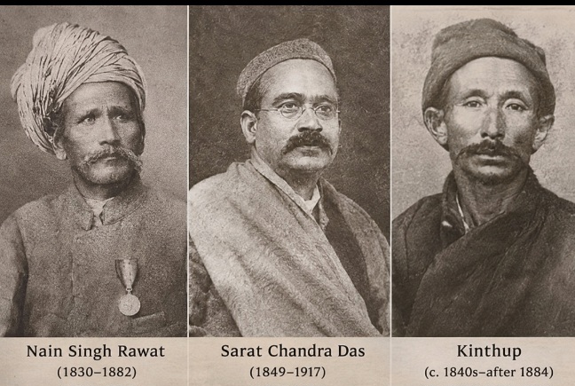
The three explorers – Nain Singh Rawat, Sarat Chandra Das and Kinthup – made different but equally significant contributions to the exploration of Tibet.
Born in 1830 in Milam village of present-day Uttarakhand, Nain Singh Rawat became one of the most celebrated Indian surveyors of the nineteenth century. Trained under the Great Trigonometrical Survey of India, he was among the indigenous explorers known as the ‘Pundits’, who undertook geographical surveys in territories inaccessible to European surveyors.
Travelling disguised as a Buddhist pilgrim, Nain Singh developed ingenious methods to record geographical information. He measured distances by counting his footsteps using a Buddhist rosary and concealed a compass inside a prayer wheel. During his expeditions between 1865 and 1875, he travelled through Tibet, reached Lhasa and recorded valuable information about its rivers, settlements, mountain passes and elevations.
His work significantly improved geographical knowledge of the Tibetan Plateau and the upper reaches of the Tsangpo. In recognition of his achievements, the Royal Geographical Society awarded him its prestigious Patron’s Medal in 1877.
Another important figure was Sarat Chandra Das, born in Bengal in 1849. A scholar, linguist and educationist, Das brought a different dimension to Tibet exploration. His knowledge of the Tibetan language and association with Lama Ugyen Gyatso enabled him to undertake journeys into Tibet in 1879 and 1881.
He travelled to important religious and cultural centres, including Tashilhunpo and Lhasa, documenting Tibetan history, religion, institutions and society. His book, *Narrative of a Journey to Lhasa and Central Tibet*, became an important source of information about Tibetan civilisation. His geographical observations also contributed to discussions about the relationship between the Tsangpo and the Dihang river system.
Perhaps the most extraordinary story belongs to Kinthup, a Lepcha explorer from the Darjeeling region. In 1880, he was sent into Tibet by the Survey of India to investigate whether the Tsangpo eventually emerged in India as the Dihang, which later becomes the Brahmaputra.
His mission involved releasing specially marked wooden logs into the river at a predetermined time so that observers downstream could identify them. However, the expedition turned disastrous when his Chinese companion reportedly betrayed him, leaving him stranded and eventually sold into slavery.
Despite years of hardship, Kinthup escaped and continued his mission. He reportedly prepared around 500 marked logs and released them into the river. Although the experiment did not provide the straightforward confirmation originally envisaged, his observations and journey added valuable geographical information. He returned to India in 1884.
The geographical mystery was subsequently clarified through further explorations, particularly the 1913 expedition led by Frederick Bailey and Henry Morshead.
Today, satellite technology can trace the Brahmaputra across international boundaries in minutes. Yet the foundations of much of this geographical understanding were laid by explorers who crossed some of the world’s most difficult terrain with rudimentary instruments and extraordinary determination.
Their journeys were also part of colonial-era surveying and strategic intelligence operations. Nevertheless, their personal courage and scientific contributions deserve recognition.
As the Brahmaputra increasingly figures in discussions about China’s hydropower ambitions in Tibet and India’s downstream water security, the stories of these pioneers acquire renewed relevance.
They were among the first to help India understand the geography of a river that remains central to its environmental and strategic interests. Their achievements are a reminder that the history of Himalayan exploration was not written by European adventurers alone. Indian explorers played a decisive role in mapping the mountains and rivers that continue to shape the subcontinent.
About the Author

Himachal ki har badi khabar, sabse pehle aapke paas
Breaking news, local updates aur exclusive stories — seedha WhatsApp ya Email par. Free. No spam.
WhatsApp Alerts
Instant news seedha aapke phone par. Ek click me subscribe karein.
Subscribe on WhatsAppEmail Newsletter
Har nayi post ka link aapke inbox me. Kabhi bhi unsubscribe karein.