
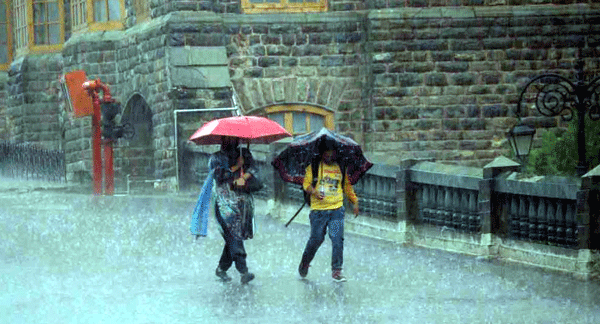
Photo used for indicative purpose only. Source: Internet
Shimla, June 2,
Himachal Pradesh is likely to witness an early and above-normal monsoon this year, according to the latest long-range forecast issued by the India Meteorological Department (IMD). The state is expected to receive more than 109% of its Long Period Average (LPA) rainfall of 734.4 mm between June and September. Weather models now suggest that the southwest monsoon could arrive in the state by June 15 to June 20, roughly ten days ahead of the usual schedule—following its unusually early onset over Kerala on May 24, one of the earliest arrivals in more than a decade.
The accelerated pace of the monsoon’s progression is being attributed to the Madden–Julian Oscillation (MJO), a powerful weather phenomenon that significantly influences tropical rainfall patterns. The MJO, which moves eastward around the equator every 30 to 60 days, is currently in a phase that promotes convection over the Indian Ocean. This enhances the formation of low-pressure systems, setting the stage for an active and potentially intense monsoon season across the subcontinent, including the hilly terrains of Himachal Pradesh.
For a state heavily reliant on monsoonal rain for agriculture, hydropower generation, and drinking water supply, this early and robust forecast brings both hope and concern. Last year, Himachal Pradesh recorded an 18% rainfall deficit, adversely affecting crop yields and reservoir levels. This year’s prediction of above-normal rainfall, especially in June—where average monthly rainfall is 101.1 mm—raises expectations of improved groundwater recharge and a boost for the state’s apple and vegetable farming economies. Early rains are expected to help kickstart sowing operations, particularly in lower and mid-hill regions.
District-level data suggest that regions like Kangra, Mandi, and Sirmaur, which normally receive high seasonal rainfall, could face even heavier precipitation this year. Kangra typically receives 1,622.4 mm, Mandi 1,097.5 mm, and Sirmaur 1,183.8 mm. Even high-altitude, semi-arid regions like Kinnaur and Lahaul-Spiti, with annual averages of 247.8 mm and 382.9 mm respectively, are forecast to receive more rainfall than usual. While this could alleviate water scarcity, it also heightens the risk of flash floods, landslides, and glacial lake outburst floods (GLOFs), particularly in ecologically fragile areas already burdened by unregulated development.
Adding to the complexity is the global climate backdrop. Over the past year, El Niño conditions—marked by warmer sea surface temperatures in the Pacific—have led to erratic rainfall across India by suppressing monsoon activity. However, meteorologists now suggest that El Niño is weakening and could transition toward a neutral or even La Niña phase in the coming months. La Niña, typically associated with cooler Pacific waters, tends to enhance the Indian monsoon by strengthening trade winds and moisture flow toward the subcontinent. The simultaneous influence of a favorable MJO and a receding El Niño significantly boosts the probability of a vigorous and early monsoon in Himachal Pradesh.
Temperature trends also point to warmer-than-normal conditions in many parts of the state, especially in lower elevations. While maximum temperatures are expected to be above normal in most regions, high hills and adjoining mid-hills may record near-average levels. Minimum temperatures across the state are likely to remain above normal, leading to humid and potentially uncomfortable nights.
Despite predictions of normal to below-normal heatwave days in June, rising humidity levels could still result in thermal discomfort, especially for vulnerable populations such as the elderly, children, and outdoor workers. Public health advisories and thermal stress alerts may play a key role in protecting these groups.
In response to the forecast, the Himachal Pradesh government is ramping up preparedness through a combination of real-time data monitoring and public awareness campaigns. Early warning systems like the SACHET app are being emphasized to disseminate timely alerts for heavy rainfall, cloudbursts, or potential disasters. Emphasis is also being placed on pre-monsoon activities such as desilting of rivers, slope stabilization, and disaster readiness in high-risk districts like Kullu, Chamba, and Shimla.
The IMD continues to stress that while above-normal rainfall may support agriculture and hydropower, it also poses risks to life, infrastructure, and ecosystems. With the growing influence of global climate change, the early and intense monsoon underscores the need for adaptive infrastructure, ecological sensitivity, and coordinated disaster response.
As Himachal Pradesh prepares for a dynamic monsoon season, timely action and informed public behavior will be essential in harnessing the benefits of rainfall while mitigating its risks. The rains this year may arrive with promise, but they demand resilience and preparedness from all.
About the Author
![]()
The HimachalScape Bureau comprises seasoned journalists from Himachal Pradesh with over 25 years of experience in leading media conglomerates such as The Times of India and United News of India. Known for their in-depth regional insights, the team brings credible, research-driven, and balanced reportage on Himachal’s socio-political and developmental landscape.


1 thought on “Above normal rainfall likely in Himachal Pradesh this monsoon, says IMD”