
Monsoon set to arrive early in Himachal, heavy rainfall likely from June 20 onwards


Photo used for indicative purpose only. Source Internet
Shimla, June 18,
The Southwest Monsoon is advancing rapidly and is now poised to cover large parts of Himachal Pradesh between June 20 and 21, nearly a week ahead of onset date of June 27, last year, stated a media communique by IMD. This early arrival comes on the back of favourable atmospheric conditions, driven by the transition from El Niño to La Niña, an active Madden-Julian Oscillation, and a western disturbance currently hovering over Punjab and its neighbouring regions.
According to the India Meteorological Department (IMD), the monsoon’s early surge has already started impacting weather patterns across the state. Light to moderate rainfall was reported in several areas on Wednesday, offering much-needed relief after weeks of persistent heat. Sundernagar recorded the highest rainfall at 5 mm, followed by Bhuntar and Gohar with 3 mm each. Mandi, Banjar, Rohru, Sarahan, Seobagh, and Jogindernagar recorded 2 mm each, while Kasauli, Manali, Baijnath, and Keylong saw 1 mm. This wet spell has triggered a cooling trend, with minimum temperatures dipping to 16.6°C in Shimla, 18.6°C in Una, 9.8°C in Keylong and Kukumseri, and 21.8°C in Mandi and Kangra.
Also read: Above normal rainfall likely in Himachal Pradesh this monsoon, says IMD
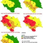
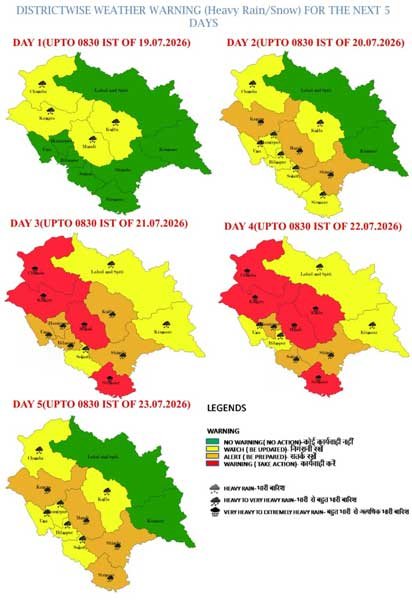
The IMD has issued an orange alert from June 23 onwards, warning of heavy to very heavy rainfall at isolated locations, especially in the mid-hill and low-hill districts. Officials predict that this year’s monsoon will be both aggressive during onset and consistent throughout its course, with rainfall estimated to reach 106 percent of the long-period average, a level that classifies it as above normal.
The next few days are expected to bring more intense weather activity. Light to moderate rainfall is likely to continue on June 18 and 19, while widespread rainfall is expected from June 20 through 24. The heaviest spells are forecast for June 22 and 23. A brief rise in temperatures by 2 to 4 degrees Celsius over the next 48 hours is anticipated, followed by a sharper drop of 3 to 4 degrees as cloud cover and precipitation increase.
Farmers and district administrations have been advised to prepare for potential flash floods, landslides, and urban flooding, particularly in vulnerable areas like Mandi, Kullu, Solan, Kangra, and Lahaul-Spiti. While the early onset of monsoon promises to replenish water reserves and support kharif sowing, much will depend on whether the rainfall remains well-distributed and manageable through the season.
About the Author
The HimachalScape Bureau comprises seasoned journalists from Himachal Pradesh with over 25 years of experience in leading media conglomerates such as The Times of India and United News of India. Known for their in-depth regional insights, the team brings credible, research-driven, and balanced reportage on Himachal’s socio-political and developmental landscape.


References:
Casino las vegas online https://neolatinswiki.site/
References:
Best casino games darrenkkhp222569.humor-blog.com
References:
Casino deutschland Spielhalle online
References:
Bellagio Casino App Online Casino Bonus 500
References:
Casino Royale cast Helsinki Spielhalle
References:
Legiano Casino Live Casino http://maps.google.com.lb
References:
Jackpot poker https://jpn1.fukugan.com/rssimg/cushion.php?url=login.littlejoys.ru/%3Fredir%3D//de.trustpilot.com/review/owowear.de
References:
Legiano Casino legal shop.litlib.net
References:
Legiano Casino Echtgeld xgm.guru
References:
Legiano Casino PayPal akmrko.ru
References:
Legiano Casino Willkommensbonus https://mcpedl.com/leaving/?url=https://hubu.ru/nilahillma
References:
Ligiano Casino kapcsolathalo.nti.btk.mta.hu
References:
Legiano Casino Bonus ohne Einzahlung https://gethuman.com/feedback/page-needs-improvement?page=https://de.trustpilot.com/review/edelkranz.de
References:
Legiano Casino Kundenservice maps.google.at
References:
Legiano Casino Login Deutschland http://www.reshalkino.ru
References:
Legiano Casino Betrug masteram.us
References:
Legiano Casino Registrierung http://cr.naver.com/redirect-notification?u=http://de.trustpilot.com/review/edelkranz.de
References:
Legiano Casino Video Review http://www.google.ac
References:
Legiano Casino PayPal board-en.piratestorm.com
References:
Legiano Casino Erfahrungen https://fftoolbox.fulltimefantasy.com/search.cfm?q=“/>
References:
https://fftoolbox.fulltimefantasy.com/search.cfm?q=“/>
References:
Legiano Casino VIP Programm forum.kw-studios.com
References:
Legiano Casino Anmeldung http://notable.math.ucdavis.edu/
References:
Legiano Casino Freispiele 87.cholteth.com
References:
Legiano Casino Tischspiele https://anonym.es/?http://abonents-ntvplus.ru/proxy.php?link=https://de.trustpilot.com/review/der-wikinger-shop.de
References:
Legiano Casino PayPal dat.2chan.net
References:
Legiano Casino Registrierung http://images.google.ch/
References:
Legiano Casino Promo Code https://trac.cslab.ece.ntua.gr
References:
Legiano Casino Gutscheincode https://tulum.ru
References:
Legiano Casino Auszahlung http://clients1.google.bj
References:
Kingmaker Casino Auszahlung unim.ma
References:
KingMaker Casino Freispiele bei Einzahlung allbio.link
References:
KingMaker Casino Einzahlung mit Apple Pay https://liy.ke
References:
KingMaker echtgeld https://vnn.bio/raulhighto
References:
KingMaker Casino Geld einzahlen https://52.cholteth.com
References:
Legiano Casino Umsatzbedingungen https://perevodvsem.ru/proxy.php?link=https://telegra.ph/Legiano-Casino-Test-2026-Willkommenspaket-von-bis-zu-500-06-07
References:
Legiano Casino Meinungen http://image.google.com.kw/
References:
Legiano Casino Mobile http://www.google.ac/
References:
Legiano Casino Einzahlung toolbarqueries.google.ps
References:
Legiano Casino Bonus ohne Einzahlung images.google.com.hk
References:
Legiano Casino Gratis Spins image.google.ci
References:
Legiano Casino Neukundenbonus http://www.24subaru.ru/
References:
Legiano Casino Echtgeld http://www.google.so
References:
Monro Casino Auszahlung Probleme http://toolsyep.com/de/open-graph-vorschau/?u=https://bybio.co/huldasewar
References:
Hitnspin casino bonus code http://www.gta.ru/redirect/share.pho.to/away?to=https://de.trustpilot.com/review/der-wikinger-shop.de&id=ACBj7&t=9BpgEvc
References:
Monro Casino Free Spins adminer.org
References:
Hitnspin bonus ohne einzahlung http://www.fouillez-tout.com/cgi-bin/redirurl.cgi?https://www.russianrealty.ru/bitrix/redirect.php?goto=https://de.trustpilot.com/review/der-wikinger-shop.de
References:
Hitnspin erfahrungen http://images.google.gg
References:
Hitnspin bonus ohne einzahlung https://forum.mds.ru/proxy.php?link=http://mobile-bbs.com/bbs/kusyon_b.php?https://de.trustpilot.com/review/der-wikinger-shop.de
References:
Hitnspin casino aktionscode http://www.google.com.pa/url?sa=t&url=https://board-en.farmerama.com/proxy.php?link=https://de.trustpilot.com/review/der-wikinger-shop.de
References:
Hit’n’spin casino no deposit bonus https://www.bigsoccer.com/proxy.php?link=https%3A%2F%2Fnotes.medien.rwth-aachen.de%2FWiT7mr7tS9Sy4Ntw3Vi1-w%2F</a
References:
Lollybet Willkommensbonus http://toolbarqueries.google.com.tw/url?sa=t&url=https://tabletennis.businesschampions.ru/away/?to=https://lollybet.com.de/
References:
Lollybet Spielautomat https://board-es.seafight.com/proxy.php?link=http://jnews.xsrv.jp/jump.php?https://lollybet.com.de/
References:
Lollybet Online Casino https://www.flashback.org/leave.php?u=https%3A%2F%2Faskmilton.tv%2F%40rhodachristy51%3Fpage%3Dabout/
References:
Lollybet Casino Erfahrungen http://maps.google.cm/url?q=http://xtpanel.xtgem.com/templates/logo.php?site=lollybet.com.de
References:
Lollybet Online Casino http://maps.google.co.bw/url?q=https://digiex.net/proxy.php?link=https://lollybet.com.de/
References:
Lollybet Echtgeld http://toolbarqueries.google.ba/url?q=http%3A%2F%2Fwww.bongmedia.tv%2F%40leonaseal8382%3Fpage%3Dabout
References:
Hitnspin casino trustpilot http://clients1.google.com.br/url?source=web&rct=j&url=https://forum.exciteme.ca/author/buffettuba96/
References:
Hitnspin verifizierung http://cse.google.bi/url?q=https://md.swk-web.com/s/v9dQzppiE
References:
Lollybet Casino Bitcoin http://amarokforum.ru/proxy.php?link=https://lollybet.com.de/
References:
Lollybet Casino Auszahlungsdauer http://cse.google.com.cy/url?sa=t&url=http%3A%2F%2Flollybet.com.de