‘Shimla Capital Region’, a NCR-Inspired Integrated Growth approach

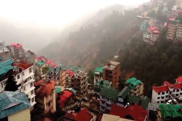
Photo used for indicative purpose only. Source: Internet
‘Shimla Capital Region’, a NCR-Inspired Integrated Growth approach
Shimla, June 23
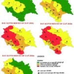
In a bid to promote integrated and planned development, as part of the Shimla planning area Development plan 2041, the Shimla Capital Region Development Plan has been unveiled, mirroring the concept of the National Capital Region (NCR). As part of the Development plan 2041, which has been made public it aims to encompass not only Shimla itself but also several surrounding towns and key activity nodes, such as Waknaghat, Kandaghat, Theog, Sunni, and Tatapani. By constituting the “Shimla Capital Region,” authorities hope to achieve the redistribution of resources and alleviate congestion in the main Shimla Planning Area.
The Shimla Planning Area, covering an area of 246.09 square kilometers, forms the core of the proposed region. However, considering the existing urbanization trends and recognizing areas with immense potential for future development, certain additional regions are being considered for inclusion.
These areas, including the catchment areas of Special Kufri and Shoghi, as well as their adjoining regions, have been identified as having high prospects for growth due to their proximity to the upcoming 4-lane road passing through Shoghi and Kufri Special Areas. Furthermore, the inclusion of pockets near popular tourist hubs like Kufri-Faagu and Mashobra-Naldehra has become imperative, given the increasing investments and development being attracted to these areas.
Also read:Highlights- Shimla Planning Area development plan 2041, General regulations
Failure to address the development potential of these high-value regions could lead to unregulated growth and encroachment by unplanned developments, undermining the very essence of the Development Plan’s objectives. To ensure planned and regulated growth, it is crucial to integrate these areas into the Shimla Planning Area and provide a comprehensive land buffer, capable of serving the region’s needs well beyond the year 2041.
Among the areas earmarked for inclusion are certain pockets situated between the upcoming 4-lane road passing through Shoghi and Kufri Special Areas and the existing Planning Area boundary. These “islands” or “no man’s land” regions are expected to witness increased accessibility and subsequent development, making their integration into the Shimla Planning Area necessary. To achieve this, entire islands, along with a 100-meter belt or the nearest natural features like nullahs or khads, are being considered for inclusion, totaling approximately 4.83 square kilometers.
Additionally, a valley belt between Bharari-Aukland and Mashobra-Naldehra ridges, covering an area of 15.17 square kilometers, is also proposed for inclusion. This region has experienced significant development in real estate and the tourism sector, making its integration into the planning framework essential.
Moreover, the area along the Kufri-Fagu Tourist belt, located between NH-5 and the Dhali-Mashobra-Bekhalti Road (old Tibet Road), has emerged as a high-potential tourism destination. Hence, an area of 0.23 square kilometers beyond the existing Planning Area boundary, in the vicinity of the Mashobra-Bekhalti Road, is being proposed for inclusion. This addition not only contributes to planned development but also enhances the forest cover within the Shimla Planning Area.
The Shimla Capital Region Development Plan, with its inclusive approach and incorporation of high-potential regions, aims to foster integrated and sustainable development in and around Shimla. By providing a framework for the redistribution of resources, decongestion, and regulated growth, this plan seeks to ensure the long-term prosperity and harmonious development of the region as a whole.
About the Author
![]()
The HimachalScape Bureau comprises seasoned journalists from Himachal Pradesh with over 25 years of experience in leading media conglomerates such as The Times of India and United News of India. Known for their in-depth regional insights, the team brings credible, research-driven, and balanced reportage on Himachal’s socio-political and developmental landscape.